
Living on a farm in Australia means driving, lots of it. The nearest grocery store is twenty to thirty minutes away, traversing a couple of low bridges, gravel roads and the Barton Highway.
That’s why it’s worth keeping chooks, a vegetable garden and fruit trees so there are always emergency food supplies. Fifty years ago there was no low bridge over the Murrumbidgee, and Esdale was much more isolated than it is now. There were eight gates between Esdale and the Wee Jasper Road. From there you could cross the Murrumbidgee at Taemas Bridge, where there’s an amazing view across the Burrinjuck Reservoir, and then wind your way up to Yass.
Going that way usually takes thirty-five minutes.
The other high bridge over the Murrumbidgee is at Cotter, where you drive beside the spillway from the dam storing water for Canberra and then have to wait for the light to allow you across the single lane bridge. That’s a slower way for us, an hour and fifteen minutes at the least, as it involves a loop up to Mountain Creek Road on Glenrock Road and brings us in to South Canberra.
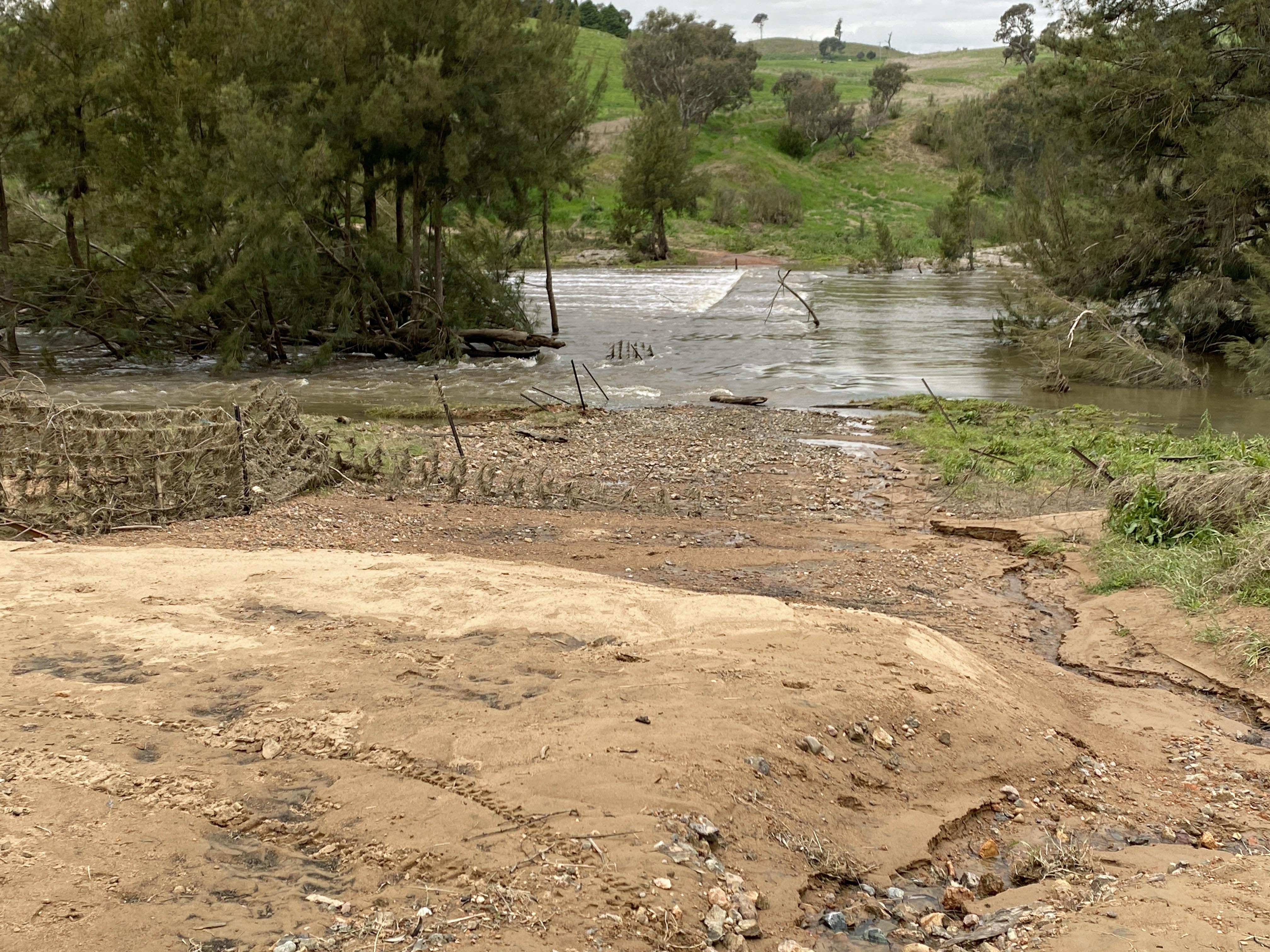
Our convenient bridge was built in 1979 to allow trucks to transport sand from the Tharwa Sands pit and dredges, downstream of us. It was built by John Hyles, completely illegally. No council would construct a bridge that is flooded multiple times a year. However, constructing a high bridge like Cotter and Taemas would have cost millions even then. Instead John used his knowledge of bridge demolition in Germany in World War 2 to build concrete piers and a slab top at a height that would not be destroyed by floods. Unfortunately, it does get covered as soon as the water is more than 2 metres deep (not particularly deep).

John went on to build another bridge at Horseshoe Road, and started on a third before the council caught up with him and made him stop.
The council has also provided us with a concrete crossing for Mullion Creek. That is also vulnerable to flash flooding, but usually not a problem for too long. Occasionally we have to push off logs that float into the road. In combination with the Carkella bridge it can be annoying after heavy rain, when the creek shoots up in the first twenty-four hours, and by the time it goes down again, the river bridge is out of action.

One time in the 1980s we were flooded in at Esdale, but Dad needed to get to Parliament House for a sitting, so a neighbour brought his front end loader across a washed-out gully to pick him up. Left behind at the house were Craig and Mum who were both smokers at the time. They only had three cigarettes between them, for four days. I’m glad I wasn’t there to deal with the crankiness.
Even non-smokers have been getting cranky with the roads this year, however. We are in our third year of excessive rain, under both La Nina and the Indian Ocean Dipole. We really wish Somalia and California would get a bit of this instead of us.
Inland and downstream of us, people are being flooded out of their houses and left with homes full of mud. We are definitely not in that kind of danger. Instead we have nuisance – roads of mud.
With the constant rain and erosion, bog holes have opened up in both old and new places. A damp patch like a bruise will appear in an ordinary piece of road, and then days later it will be a sea of muddy soup, impassable. Even when there are bits that look solid, they aren’t. My boots are still drying from the last time I tried to test one.
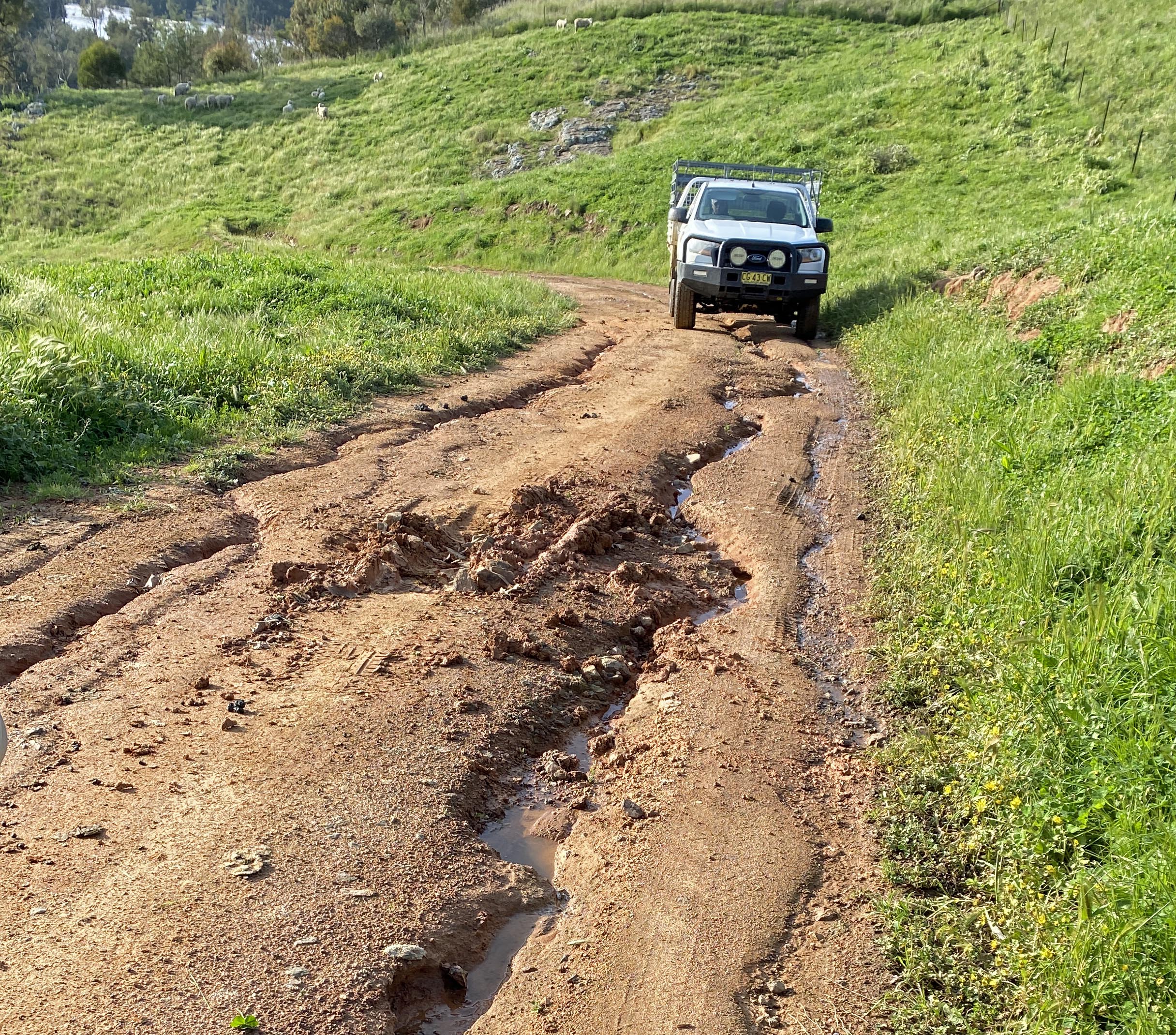

The paddocks have been off limits for months, so there’s no easy way round the soup holes.
The best cure for a soup hole is digging out, lining with erosion stop fabric and filling with rock followed by gravel. That we were luckily able to do near the Esdale entry a few months ago. Unfortunately, so much of the roads have collapsed recently that dozens more holes opened up. Back in 2020, during the Covid lockdowns, it didn’t matter when we were flooded in for weeks at a time, because we had nowhere to go. Now we have appointments. After we realized that we weren’t going to be able to come and go at will, our neighbour Andrew kindly dropped me on one side of an impassable hole and Craig picked me up on the other, resigning ourselves to waiting until we could get home.

With the bridge flooded and the long alternate routes continuing to turn to soup, we ended up staying in town for most of a month. By the time we returned we looked like a family of refugees with all our possessions on the back of the truck.

Coming home took two hours, carefully navigating the huge washouts and slush holes. Choosing a path among the Grand Canyons is always a challenge.

While we’d chosen the town side of the river, our neighbours Andrew and Leonie had to relocate their annual Cup Day lunch because their house was inaccessible. For weeks they’ve had to keep a second vehicle on the far side of the main mud-wallow section. In the end they were reduced to transporting groceries by wheelbarrow on planks.
Finally, the last couple of days have begun to dry off a little and there’s frantic work going on to get the roads functional again. Unhelpfully, the snakes are also out and about trying to get warm after all the rain, and one launched itself at James the Bobcat Master while he was wading through a mud wallow working out what to do next. Exactly what you don’t want, to need a hospital with no road available. Luckily it missed.

The low bridge has a metre deep channel in front of it at the moment, but I’m hoping that will be fixed in time to get to my appointment tomorrow. Fingers crossed.

one of your busy love C
LikeLike
muddy marvellous
LikeLike